

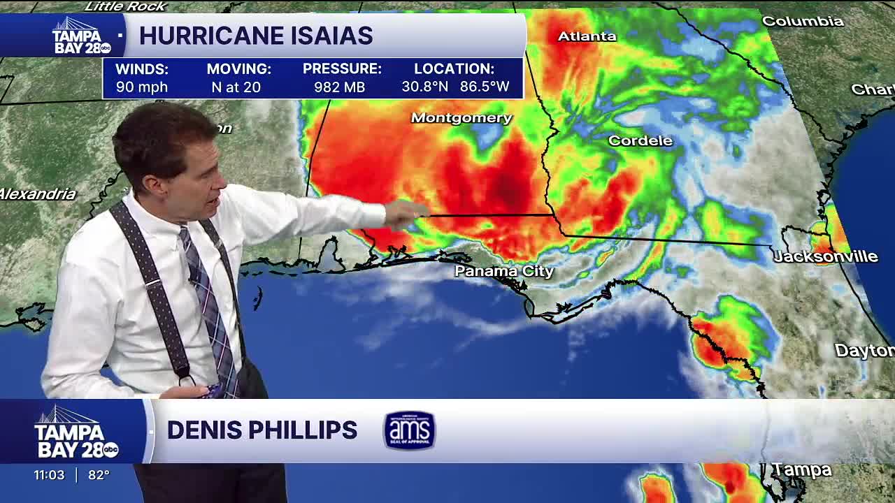


Isaias, the first hurricane of the Atlantic season, has made landfall near Destin with maximum sustained winds of 105 mph, the National Hurricane Center reports.
Maximum sustained winds are 115 mph, as of the 5 p.m. Friday update, with some weakening expected over the next several hours.
Tampa Bay 28 Chief Meteorologist Denis Phillips shares his latest thoughts:
9:45 p.m. update
Landfall. The NHC has announced landfall in Destin with winds of 105 mph. Panama City has reported surge levels of 5.6 feet.
9:30 p.m. update
NWS Doppler Radar data indicate that Hurricane Isaias made landfall near Destin, Florida, around 830 PM CDT (0130 UTC) with maximum sustained winds of 105 mph (165 km/h). The estimated minimum central pressure is 971 mb (28.67 inches).
8:45 p.m. update
Hurricane Isaias Update: Landfall about to occur near Destin. Pressure has gone up significantly the past 90 minutes. The eyewall appears to have collapsed with this pressure rise and shear we've been predicting. Winds gusting between 90 and 100 mph around and near what's left of the eye.
8 p.m. update
Isaias is nearing landfall with maximum sustained winds of 110 mph.
7 p.m. update
LOTS of spin as Hurricane Isaias approaches landfall.
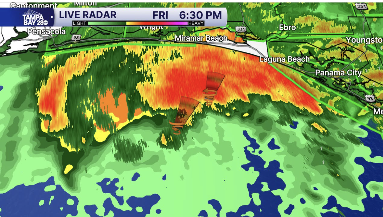
6:30 p.m. update
Always keeping an eye on "wobbles" upon landfall, but again, hurricane winds extend 35 miles out now. Storm wind field is expanding as shear hits it. Ultimately, the worst of the winds will be between Pensacola and Destin. Surge will be high along that entire area. Remember, a hurricane is not a single point. Impacts will extend over a much larger area. However, the worst of the winds, which I think will be around 95-100 at the surface (higher gusts) will extend only about 5 to 10 miles from the center.
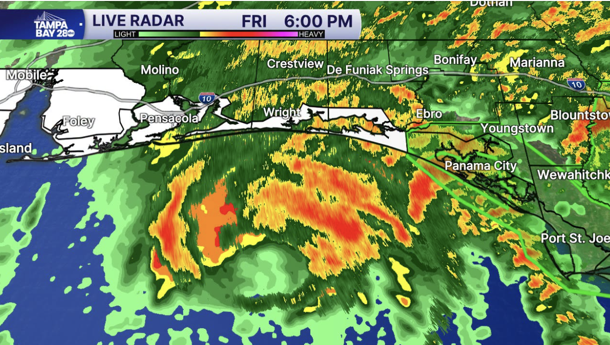
6:10 p.m. update:
Cat 3 Hurricane Isaias is moving North at 17 mph. Given the center of the eye is just over 50 miles away from the coast, that's landfall in 3 hours. Hurricane force winds extend 35 miles out. The coast should start feeling the hurricane force winds by 7 p.m. Eastern time.
5 p.m. update:
Winds now down to 115 mph. Still a Category 3 hurricane. Some weakening should occur over the next several hours but it's still expected to have winds around 100 mph at landfall. Landfall will be right around Pensacola this evening.
2 p.m. update:
As of the 2 pm update from the NHC, Isaias still a strong category three storm with winds of 120 mph. 160 miles from Pensacola, FL. Tornado watches are up for Alabama, Georgia and Florida
9 a.m. update:
1. Recon has found winds of 120 mph in Isaias. It is officially a Category 3 hurricane. No real surprise here. NHC was predicting 115, and we've been saying this could go Cat 3 for days with all that warm water in the Gulf. Where does he go from here?
2. Isaias is traveling NNE, and the final track has not changed. This will have a major impact on Pensacola later tonight. University of West Florida WILL see direct impacts later tonight. There will be power outages, and trees will go down. Anyone in this area should RUSH to prepare and follow EOC and local law enforcement directions. I am NOT saying whether or not to evacuate; that's something I can't do. However, I will say if someone in the Pensacola area IS evacuating, the Tropical Storm force winds should begin to move in by around 2pm.
3. The storm will begin to encounter some pretty significant shear later this afternoon, which should not only stop its intensification; it should also weaken it somewhat just before landfall. However, it will still be a formidable hurricane with winds of around 95 to 100 mph. The wind field will also expand with this shear, but hurricane-force winds will still only extend about 30 miles, with the WORST of the winds really only reaching 5 or 10 miles. Again, Pensacola through Fort Walton Beach will get the worst of Isaias.
4. A surge of 6 to 9 feet (Think Helene) will occur from around the Mobile Bay to near Grayton Beach. If you or someone you know lives along the water, please convince them to get out NOW if they are in a mandatory evacuation zone. Water is always the biggest threat to lives in a hurricane. They still have a few hours to get out safely if they choose (or are told) to do so.
5. Again, for people in Tallahassee with kids at Florida State University and Florida A&M University, they will see breezy conditions with winds possibly gusting up to 35 mph. Do what you feel is best, but in my opinion, they won't even see tropical-storm-force winds. Officially, the NWS forecasts "Breezy" conditions for Tallahassee and no tropical-storm-force winds.
6. There will be a tornado threat to the North and East of the Center of Isaias, and a tornado watch will likely be issued later today.
7. Again, NO impacts to the Tampa Bay area other than a bit of coastal flooding at high tide later tonight and tomorrow.
8. If you, or your family or friends live between Mobile and Pensacola, now is the time to finish your preps and prepare to either move or ride this storm out. If you scroll down on my page, I listed our family's hurricane prep list. It's pretty solid and can be helpful if you lose power...which some folks in Pensacola almost assuredly will.
9. Isaias will make landfall later this evening (Between 10 and midnight) and will be long gone by daylight on Saturday morning. It will weaken VERY quickly once it makes landfall. There will be about a 4- to 6-hour window where things in the Western Panhandle will get very scary. We live on the Gulf. We've come to expect this threat, but you can never really imagine what these storms are like until you actually live through them. Most of us know from experience. If you live in the impacted area, don't take it lightly. Finish up your preps, and if you are evacuating from a surge area, do it NOW. You still have around 12 hours before the water begins to rise, and as of 9 a.m., about 6 hours before the winds start to really pick up.
10. If you're riding it out, charge all your phones and extra batteries NOW. Again, find my list from yesterday and do everything you can before the storm arrives. Rule #7. Now is NOT the time to freak out; it's the time you make decisions to keep your family safe. You've got this! We'll update 24/7 as always
8 a.m. update:
Hurricane hunters inside the storm found Isaias's winds are now up to 120 mph, making it a Category 3 storm. Next track update at 11 a.m.
October 8
11 p.m. update:
Winds are now 105 mph, making it a strong Category 2 hurricane. The track has not changed. Landfall will be around Pensacola later Friday evening. No impacts on the Bay Area other than a bit of coastal flooding at high tide on Friday and Saturday.
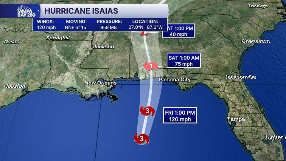
10 p.m. update:
Still tracking rain out there with Flood Watches in effect across part of the area. You may notice the "Storm Surge Watch" for Levy County. Again, we will see some coastal flooding (water rise) at high tide on Friday and Saturday around 18 inches to 2 feet. But a surge is NOT expected in our area given the track of Isaias is so far to the West and it's not a particularly large storm.
6:30 p.m. update
Isaias Tropical Thoughts:
1. Winds are now 100 mph. Just a little nudge to the East with this track. Ultimately, very close to Pensacola at landfall.
2. Isaias will weaken as it approaches the coast. There is a ton of shear out in the Gulf, and there's just no way it doesn't weaken the storm before landfall. Even so, winds of 80-100 mph seem likely for the Western Panhandle.
3. Impacts on the Bay Area...little to none. We will see a bit of water rise at high tide later Friday and into Saturday. It's not a surge, so to speak, but the end result will give maybe 18" of rise at high tide. To use a local example, the bayou at Tarpon Springs can often rise into the street when there is a King Tide. That type of increase is possible; however, Levy County (One up from Citrus) has a bit better chance of seeing a couple of feet of surge.
4. For those who still don't believe me, this is NOT Milton or Helene. It is not going to change course. Take a breath and relax. I'll be honest... long-range models show nothing for weeks to come. The season runs until November, but this COULD easily be the only threat we see this season. A threat that stayed well to the West of the Bay Area.
5. As for the Western Panhandle, Isaias is a significant threat. There will be power outages. There will be surge. There will be winds of 80 to 100 mph. Do NOT take this storm lightly. No, it won't be a major hurricane at landfall, but it will pack a punch. Don't dismiss it if you live anywhere from Mobile to Pensacola.
6. Lastly, hurricane winds only extend FIFTEEN miles out. This is NOT a big storm. Most areas within 100 miles of landfall will see tropical storm-force winds.
7. Rule #7. If you're in the path of the storm, now is not the time to freak out. It's the time to make and enact plans that you've put together for this type of situation. You've got this! I will post a list of hurricane preps my family has put together over the years. Hopefully, it might give you a few ideas if you live where the storm makes landfall.
8. And for folks asking about Florida State University and Florida A&M University, I just don't see much of a problem. I don't think evacuations will be needed. However, University of West Florida will see some significant impacts, with power outages likely.
5:15 p.m. update:
Hurricane Isaias Cat 2 Hurricane: 5pm advisory is out. Winds are now 100 mph making Isaias a Cat 2 hurricane. The track was nudged a BIT to the East. No significant changes to impacts with this advisory.
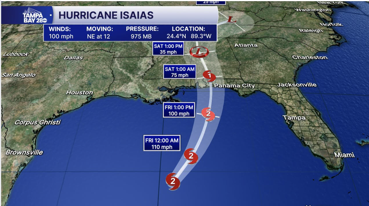
2 p.m. update:
As of the 2 PM update from the NHC, Hurricane Isaias has maintained maximum sustained winds of 85 mph and still expected to strengthen over the next few hours. Those in the path need to finish up preparations and make plans swiftly. New track at 5 PM and we will share it with you here!
5 a.m. update:
The 5 am track update made little change to the track. Honestly, don't expect this to change much today. All of the models are locked in somewhere in where the cone is now with the most likely location being Mobile Bay to Pensacola Friday evening after sunset. Isaias will not be at peak intensity during landfall. Most of the models are at or below the NHC intensity levels. All show the storm weakening as it approaches the coast due to strong shear.
October 7
11:39 p.m. update:
Breaking: Isaias is now a hurricane with winds of 75 mph. Next track update will be at 5am.
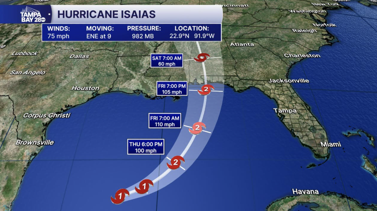
11pm update: No changes to the track. Winds are up to 70 mph. NHC now has Isaias a Cat 2 at landfall with winds around 105 mph. They never "officially" forecast Cat 3, but 110 is 1 mph shy of Cat 3 Major Hurricane Status. So for all practical purposes, it's Cat 3. Either way, if you live between Pensacola and Mobile, take this storm seriously.
7 p.m. update:
Looks like we could see some storm surge Friday into the weekend into the Tampa Bay. 1-3” feet if the slightly easterly track holds.
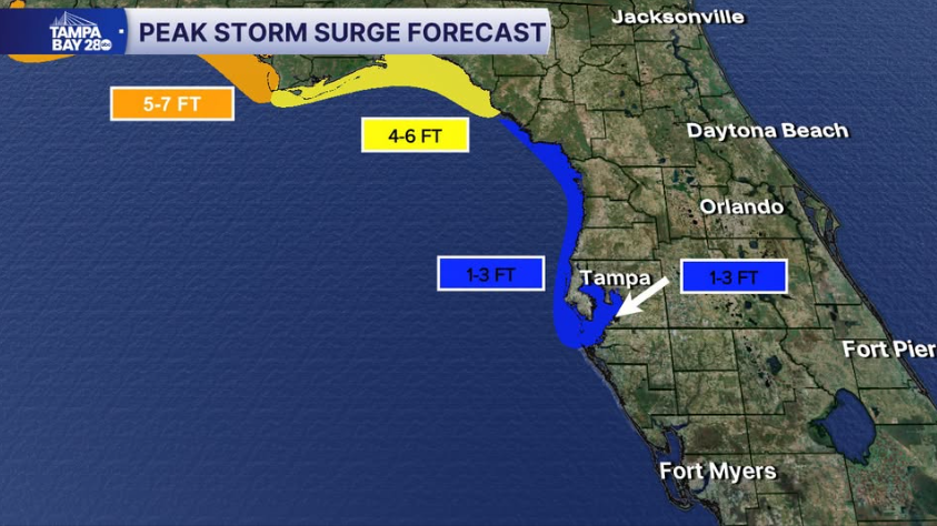
5 p.m. update:
As of the 5 PM update from the NHC, Isaias has strengthened to winds of 65 mph. Still forecasted to become a hurricane as early as tomorrow morning.
3 p.m. update:
Isaias now has winds of 50 mph. There will be NO impacts for the Tampa Bay area.
I suspect we not only have the season's first hurricane, it is entirely possible this becomes a major hurricane. Residents along the Northern Gulf Coast from Pensacola to Mobile Bay will likely see hurricane conditions starting Friday afternoon or evening. Tropical Storm winds arrive earlier. There's a good chance Isaias starts to weaken some upon landfall as it encounters some pretty solid shear.
I'll have a new update at 5 p.m. when the NHC issues an updated track.
2 p.m. update:
Isaias now has winds of 50 mph. There will be NO impacts for the Tampa Bay area.
I suspect we not only have the season's 1st hurricane, it is entirely possible this becomes a major hurricane. Residents along the Northern Gulf Coast from Pensacola to Mobile Bay will likely see hurricane conditions starting Friday afternoon or evening.
Tropical Storm winds arrive earlier. There's a good chance Isaias starts to weaken some upon landfall as it encounters some pretty solid shear.
I'll have a new update at 5 p.m. when the NHC issues an updated track.
Along with hurricane and tropical storm watches, surge watches have been issued from the Florida Big Bend west to southeast Louisiana. A storm surge of 5-7' is possible near and east of where the center makes landfall.
HURRICANE RESOURCES

MacDill Air Force Base housing lawsuit grows to 105 military families alleging unsafe conditions, mold
A lawsuit against the company managing privatized housing at MacDill Air Force Base has more than doubled in size, with 105 military families now alleging they lived in unsafe and unhealthy conditions. The amended complaint represents more than 450 people and spans 924 pages.
